Aerial Survey & Mapping
Go Further, Map More with ARACE

Go Further, Map More with ARACE
In today's world, accurate and timely geospatial data is more critical than ever. But let's be honest, traditional surveying methods can often be slow, expensive, and sometimes even risky.
That’s where ARACE UAVs come in, transforming how professionals like you capture the world from above. Imagine covering vast tracts of land in a single flight, gathering precise data with unparalleled efficiency – that's the ARACE difference.


Our UAVs aren't just drones; they're powerful, reliable tools specifically engineered to meet the demanding needs of aerial survey and mapping professionals. Here’s how ARACE platforms give you an edge:
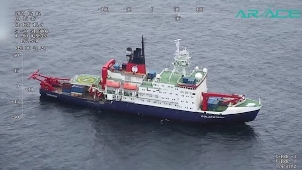
Unmatched Endurance: Cover Vast Areas in Single Flights Forget constant battery swaps and multiple deployments. Our UAVs, especially a powerhouse like the Phoenix, offer industry-leading flight times. This means you can map larger areas more efficiently than ever before, saving you valuable time and resources.
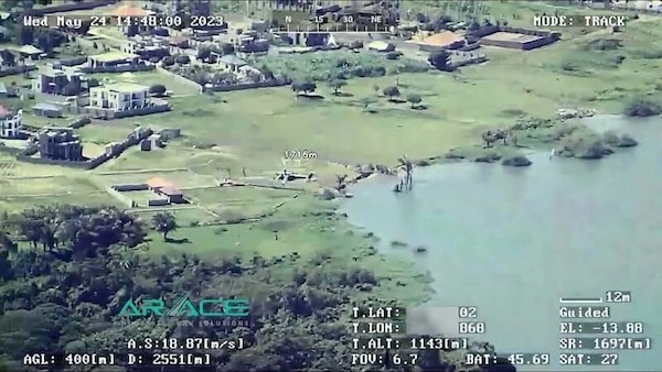
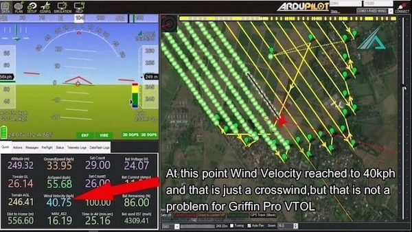
Precision Data, Every Time: Capture with Confidence Accuracy is paramount. ARACE UAVs provide exceptionally stable flight performance, crucial for acquiring high-resolution data. They are designed to seamlessly integrate with a wide range of professional-grade sensors, ensuring you get the detailed imagery and measurements you need.
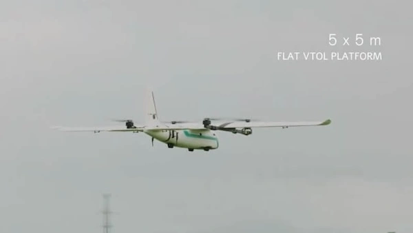
Versatility at its Core: One Platform, Many Possibilities Your projects are diverse, and your tools should be too. With easily swappable payload options, a single ARACE UAV can be quickly configured for various tasks – from photogrammetry and LiDAR scanning to multispectral imaging.
Smart Economics: Boost Your Efficiency and Bottom Line By significantly reducing the need for extensive manpower and speeding up data collection, ARACE UAVs offer a highly cost-effective solution. Get more done, faster, and see a real return on your investment.
Safety First: Map Challenging Terrains Without the Risk Some sites are difficult, dangerous, or even inaccessible for traditional ground crews or manned aircraft. Our UAVs can operate safely in these environments, gathering critical data while keeping your team out of harm's way.
Land Surveying & Cadastral Mapping Creating highly accurate boundary maps and topographical surveys with speed and precision.
Construction Site Monitoring Tracking progress, calculating volumes, and ensuring projects stay on schedule with up-to-date aerial insights.
Agricultural Mapping & Precision Farming Optimizing crop health, managing resources, and improving yields with detailed field data.
Environmental Monitoring & Conservation Assessing land changes, monitoring wildlife habitats, and supporting vital conservation efforts.
Mining & Quarry Operations Efficiently managing stockpiles, planning operations, and ensuring site safety with regular aerial surveys.
Infrastructure Inspection Safely and thoroughly inspecting bridges, power lines, pipelines, and other critical infrastructure.


Phoenix For when you need to cover truly vast areas, its world- record endurance is unmatched.
Griffin Pro The go-to for operations in challenging terrains or windy conditions, where its agility and resilience shine.
Angel Perfect for rapid deployment and surveying smaller sites with exceptional ease of use and portability.
At ARACE, we're more than just a UAV provider; we're your partners in innovation. We’re passionate about helping you achieve outstanding results with cutting-edge, reliable, and user-friendly aerial solutions.


No CGI, these videos speak for themselves.